

The increase in global temperatures caused by human activity is contributing to sea-level rise worldwide. Humans are discharging vast amounts of greenhouse gasses into the atmosphere resulting in the melting of glaciers and the expansion of seawater as it warms. Sea-level rise is causing many issues, including coastal flooding, displacement of communities, erosion, economic impacts, and contamination of freshwater sources. People around the globe, climate change migrants, are being forced to relocate from their homes because of the devastating effects of climate change. Sea level has risen eight to nine inches since 1880, fully three inches within the last 25 years. A new finding by National Oceanic and Atmospheric Administration (NOAA) claims that the U.S. coastlines will experience an additional rise of 10 to 12 inches by 2050. Additionally, as of 2023, it is estimated that properties in vulnerable areas in the U.S. are overvalued by $121 billion to $237 billion because flood hazard maps are out of date. When these unacknowledged risks become realized, homeowners stand to lose significant equity, with low-income homeowners suffering the most.
Using their state-delegated land use regulatory authority, local governments can reconsider when and how they allow coastal development in the wake of sea-level rise. Municipalities, including Kaua’i County, Hawaii, Boston, Massachusetts, and Norfolk, Virginia are reconsidering their rules for development and construction along the coast.
The County of Kauai, Hawai’i is one of the first in the nation to regulate construction and development based on the impacts of sea level rise, specifically passive flooding and annual high-wave run up. New construction in areas prone to the effects of a projected 3.2-foot increase in sea level rise by 2100 must be elevated on stilts due to the new mandate. This rule also applies to reconstruction where the expenses for enhancements will amount to 50% or more of its market value. For new construction of residential structures and substantial improvements, the lowest floor (including basements) must be elevated at least two feet above the highest sea level rise flood elevation (SLRFE) located within the respective building footprint. For new construction of nonresidential structures and substantial improvements must elevate the lowest floor (including the basement) at least one foot above the highest sea level rise flood elevation located within the respective building footprint. This mandate will help protect both the existing and future infrastructure needed to support these buildings.
Kauai’i County implemented this mandate to address future projections rather than historical data on sea-level rise. The County relied on innovative computer models from UH Mānoa Climate Resilience Collaborative. Kauai’i is being progressive; as science tells us, the impacts of sea-level rise will only worsen in the future.
The city of Boston, Massachusetts has advanced the 2016 Climate Ready Boston plan by adopting the 2021 Coastal Flood Resilience Overlay District (CFROD), which restricts coastal development. The objective of this effort is to designate a zoning overlay district and adopt resilience design guidelines to promote building adaptation and protection from future flood risk. The city ordinance states that it aims “to protect persons and structures from the effects of sea-level rise and storm surge associated with climate change by: promoting resilient planning and design, providing consistent standards for the review of projects, maximizing the benefits of long-lived investments in coastal resilience, promoting the co-benefits of sustainable designs that address multiple climate impacts, advancing adaptation strategies that are future-looking and draw on best practices for long-term resilience, and encouraging design that responds to the unique conditions of Boston’s building types, advancing resilience for individual buildings, district-scale resilience plans, and enhancing the public realm.”
The city’s guidelines recommend flood-resilient strategies for developers to consider when applying for permits. For example, in the flood resilient strategy, a building subject to wave action should be elevated on an open foundation to protect the building from high to moderate height waves which would erode or cause structural damage to the foundation. In areas not subject to wave action, construction should elevate on solid foundation walls and fill subgrade space. In addition, wet floodproofing is recommended to allow flood waters to enter and exit portions of a structure. Waterfront parks should be designed to function as barriers to flooding. The spaces should utilize flood damage-resistant materials, elevate platforms, and establish flood walls.
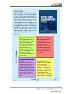
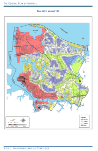
As a coastal city, Norfolk, Virginia is facing the highest rate of sea-level rise on the US East Coast, 4.5 mm per year. This sea-level rise will impact industrial infrastructure, transportation, healthcare, educational facilities, and cultural and historical landmarks. The City of Norfolk has created a land use strategy in response to the challenges of sea-level rise. Norfolk has developed Vision 2100 and the Citywide Resilience Zoning Strategy. Norfolk has separated itself into four different vision areas that represent four combinations of asset type and flood risk. The overall goal is to decide where development should be incentivized, where development cannot be prevented or moved, and where development can be discouraged.
The objective of this plan is to focus major infrastructure investments on more resilient areas, improve transportation connections, generate tools and incentives to develop a more resilient housing market, and seize the economic opportunities of emerging resilience-based industries. Within this zoning strategy, Norfolk has divided itself into four color-coded vision areas – Design New Urban Centers (green), Enhance Economic Engines (red), Establish Neighborhoods of the Future (purple), and Adjust to Rising Waters (yellow). The different areas represent a different combination of present or future key assets and flood risks.
The “Red Areas – Enhancing Economic Engines” contain high-value assets faced with high levels of flood risk. This area includes the downtown waterfront, neighborhoods adjacent to the Naval Base of Norfolk, ports and shipyards, and universities and medical facilities. In response to these challenges, Norfolk determined that this area should be secured with major flood-control investments that preserve access to it by implementing flood walls, tide gates, pumps, and green infrastructure.
The “Yellow Areas – Adapting to Rising Waters” have fewer key community assets but a higher risk of flooding. Norfolk plans to focus investments on infrastructure that “extends resilience”, educate the public about the risk of recurrent flooding, develop programs to help property owners recoup economic value that is lost to sea-level rise all within these yellow areas. The city is seeking to find new protection mechanisms because some of the neighborhoods are historic areas.
Within “Green Areas – Designing New Urban Centers”, Norfolk aims to redevelop these areas with an eye to transit-oriented urban centers. In these areas, there is both high-value existing uses (hospitals) and underdeveloped parcels (parking lots). It occupies zones of the city at relatively lower risks from sea-level rise and recurrent flooding. Urban centers will be reasonably safer from flood risk with proper planning. It can accommodate projected increases in population as well. The plan is to capitalize on opportunity to create a model urban form of development in these areas.
“Purple Areas Establishing Neighborhoods of the Future” are areas that cover stable neighborhoods that are at relatively lower risk of flooding from sea-level rise. These areas could benefit from additional incremental investments in connections with city economic centers. The city of Norfolk hopes to make investments that enhance neighborhood attractiveness while maintaining affordability. The plan is to redevelop underperforming commercial and multifamily residential properties.
Municipalities implementing these mandates and incentives will reduce the impact sea-level rise has on communities and economies. Being progressive and acting is the only way we will reduce the impacts of sea-level rise that are to come in the future.
This article is part of a series from the Land Use Law Center that explores how local governments can implement Climate Resilient Development (CRD) as defined in the Sixth Assessment Report of the IPCC. CRD requires innovative reform of land use planning and regulation by local governments. The series presents and analyzes numerous local laws and policies capable of adapting to and mitigating climate change to create equitable and sustainable neighborhoods, achieving “sustainable development for all.”
Author: Jenna Faucheux, 1L Land Use Scholar