
The land is sinking, and the seas are rising. Coastal cities worldwide struggle to deal with the impact of climate change and the rising tides. Sea level rise impacts towns and communities around the globe. Their destruction has shown cities and towns the importance of implementing an adaptive framework to help mitigate sea level rise.
Effects of Sea Level Rise
So, what happens when there is flooding due to sea level rise? Stormwater is discharged from drains and into natural bodies of water, leading to the pollution of urban areas. Apart from flooding and shore erosion, water quality concerns can, in turn, affect food quality. Coastal cities are among the highest areas impacted by sea level rise.
Norfolk, Virginia, is one of many coastal areas that are highly impacted due to its geographic location. The water contamination became so bad the city began to discourage residents from eating oysters caught in the area.
Flooding from high tides and storms is becoming more frequent. The Chesapeake Bay region is experiencing subsidence, which means the land is naturally sinking. It is sinking at the rate of 1.1 to 4.8 millimeters per year.
The detrimental impact of the rise in sea level has led Norfolk to create a comprehensive plan focused on combating sea level rise. Multiple projects and plans have been implemented over the years, such as the Shoreline Stabilization Project.
This initiative is a special plan within the Norfolk comprehensive plan contained an overlay district located along Mayflower Road, which borders the Knitting Mill Creek. This project focuses on adapting to sea level rise with bioswale and native shrubbery.
Bioswales are linear, vegetated ditches that allow for the collection, conveyance, filtration, and infiltration of stormwater. A bioswale replaces the traditional concrete gutter with an earthen one. The vegetation reduces the water’s velocity, allowing for treatment and infiltration. Because they behave like a gutter, these trenches are best suited along roadsides or parking lots. The bioswale is planned to be retrofitted between the shoreline and the road. This incorporation will also allow for the adaptation of future landscapes.
The Knitting Mill Creek is a part of the shoreline stabilization project and is within the overlay district that Norfolk considers a vulnerable area. This area comprises a small tidal creek within the city and a tributary to the Lafayette River.
The concept and design of this project provide a long-term approach to the stormwater infrastructure. Wetlands, wet ponds, and manual vegetation placement were implemented as a natural solution to buffer stormwater runoff and stabilize the shoreline that borders the knitting mill creek.
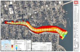
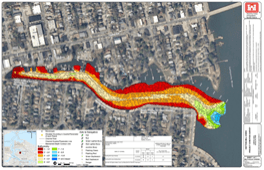
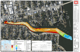
The condition survey maps from the U.S. Army Corps of Engineers Digital Library show the project’s success from 2016, 2020, and 2023. One can see how the water depth and density have changed over the years for the better.
Living shorelines also have a large part in stabilization. They “connect the land and water to stabilize shorelines, reduce erosion, and provide valuable habitat that enhances coastal resilience,” unlike concrete seawalls, which impede the natural growth of plants and animals.
However, there are some areas where seawalls made from man-made materials other than vegetation can serve as beneficial. Usually, bulkhead shorelines are constructed in areas vulnerable to storm surges and powerful waves.
The Ohio Creek Project
In 2016, Norfolk was awarded a 112-million-dollar federal grant from the National Disaster Resilience Competition. This grant was awarded for their Ohio Creek Watershed Project, which was initially created as a university project by architecture students from Hampton University in Virginia.
The project addresses shoreline erosion through the use of a living shoreline. Public spaces and neighborhoods have also been improved through additional storm drainage systems and through the implementation of natural landscapes in local parks.
The Shoreline Stabilization Project and the Ohio Creek Project are not the only ways Norfolk is combating sea level rise. The city has also modified its ordinances and zoning codes.
Ordinances and Zoning Codes
The updated ordinances and zoning codes address highly vulnerable and susceptible areas impacted by sea level rise; the city of Norfolk has included these areas to be within its Coastal Resilience Overlay District. Ordinance 3.9.18 is titled the Coastal Resilience Overlay.
The Coastal Resilience Overlay contains codes and regulations for high-risk flooding areas pertaining to new development and redevelopment within the annual chance flood zone. These regulations require that developments be three feet above the base flood elevation. Electrical systems must be raised one foot above the base flood elevation., The ordinance prohibits basements, limits paved parking, and requires landscaping to consist of salt-tolerant and native species.
Overall, one can see how Norfolk is an excellent example of how cities can adapt and mitigate sea level rise. Implementation of green infrastructure, living shorelines, and ordinances not only mitigate the effects of rising sea levels through natural solutions, but also enhance the beauty of the local areas.